Wizmo Soaring Guide
- This guide was put together with the assistance of
local
clubs. These clubs have negotiated most of the sites. Please
pay special attention to the access restrictions to avoid the loss of the
site to all.
To use this guide to its full potential you need a browser capable of full Java 1.02
compatibility. Unfortunately due to Microsoft’s' great fear of Java and its claim
against their monopoly, most of their Browsers have some convenient bug that prevents
these pages working. I have tested these pages on Netscape 3.01, and IE 4. Some of the
features work on IE3.01 and IE 3.02. I assume that Netscape 3.01 and above, and Mac/UNIX
browsers will be compatible. Please inform me if you have any trouble with any software,
and I will try and fix it
How to use this Guide
Your main navigation tool is in the left portion of the screen. The Top Cloud
accesses the Current Weather screen.
This page allows easy access to actual weather conditions throughout the UK. The
Lower F-Cloud shows a Weather Forecast Model
output. These pages display detailed weather predictions from various sources for
Northern Europe. The Soaring Paraglider and cliff access the Site Guide.
Currently I am waiting for permission from the local clubs, before publishing the pages. I
have included samples to show the expected format.
The welcome page includes descriptive pointers to these links. The main links are
always visible when using a frame compatible browser. If the soaring Paraglider animation
does not work properly you are probably using an early version of Netscape. Using the
small Netscape Icon you can select a compatible (but slower) image.
Where appropriate a form icon is provided for you to add other information to the site.
If you would prefer to contact me via e-mail links are provided on most pages.
Current Weather
 The top cloud is always visible in the top left corner of the
browser window. Click it to show a graphical image of the U.K. with symbols indicating the
position of Automatic Weather Stations. Click over the icon of interest to access the
external link which displays the latest data including wind speed direction, temperature,
and cloud cover. The data comes from various sources
The top cloud is always visible in the top left corner of the
browser window. Click it to show a graphical image of the U.K. with symbols indicating the
position of Automatic Weather Stations. Click over the icon of interest to access the
external link which displays the latest data including wind speed direction, temperature,
and cloud cover. The data comes from various sources
Blue Diamond
- NWS (US National Weather Service, mostly
airports)
Green Cirlce - NOAA (US National Oceanic ,
mostly oil rigs)
Red Squares - Others - mostly universities
Forecast Weather
 The F-Cloud image is always visible in the top left corner of
the browser window. Click it to display the forecast weather. Linked images show data for
the next six days. The models are more accurate the nearer the time. Two displays are
shown for each forecast. The first is a pressure map. The second interprets Wind speed and
Humidity. Wind speed is displayed as Ticks. Each full tick (or barb) represents 10 m/s (22
mph). Humidity is displayed in green. The darker the shading the greater the chance of
rain. Clear areas usually indicate clear or high level cloud.
The F-Cloud image is always visible in the top left corner of
the browser window. Click it to display the forecast weather. Linked images show data for
the next six days. The models are more accurate the nearer the time. Two displays are
shown for each forecast. The first is a pressure map. The second interprets Wind speed and
Humidity. Wind speed is displayed as Ticks. Each full tick (or barb) represents 10 m/s (22
mph). Humidity is displayed in green. The darker the shading the greater the chance of
rain. Clear areas usually indicate clear or high level cloud.
These pages can take some time with slow connections, although once downloaded each
image can be immediately shown in full resolution when selected. Click on the image to
display it full detail. Displaying an individual image before fully loaded will increase
the download speed of that image.
Site Guide
 The soaring Paraglider is always visible on the left side of the
screen. Click anywhere on the image to access the Country Map. Use the Country Map to select your area of interest.
A Local area map will replace the Map. The Local area map requires a Java compatible
browser, but is capable of quickly showing the best site in the region to fly. Selecting
the site of interest from the Local Map
to bring up detailed information. The detail pages include details of the
negotiating club and appropriate restrictions. Also included are full descriptions
including hazards, parking details, take-off, landing points, Site
Map, and specific details are also provided where available.
The soaring Paraglider is always visible on the left side of the
screen. Click anywhere on the image to access the Country Map. Use the Country Map to select your area of interest.
A Local area map will replace the Map. The Local area map requires a Java compatible
browser, but is capable of quickly showing the best site in the region to fly. Selecting
the site of interest from the Local Map
to bring up detailed information. The detail pages include details of the
negotiating club and appropriate restrictions. Also included are full descriptions
including hazards, parking details, take-off, landing points, Site
Map, and specific details are also provided where available.
Country Map
The Country Map is your navigation start point, and displays a map of the UK with
county boundaries. The map is divided into various regions. Click on the region of
interest to display the Interactive Local Map
Currently the regions are Scotland, Cumbria, North East, Isle of Man, Northern Ireland,
Eire, North Wales, Lancashire, Yorkshire, Derbyshire, Midlands, Thames Valley, South
Wales, Cornwall, South West, South East, and East Anglia.
Local Map
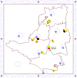
The local map includes coloured icons with red arrows indicating the wind directions
required. The size of the icon is proportional to the soarable length of the hill. The
shadow depth is proportional to the quality of the site. The quality is based on the
access, XC possibilities and ease of landing. Moving the cursor over the icon will display
the site name. Clicking the icon will take you to the Site Detail page
(some clubs have requested that data is held on thier own pages so direct links are
provided in these cases). The colour indicates the site access type
Green
- Open Site
Yellow - Club Site
Orange - Strictly Members Only
Black - Site Closed
For example, indicates a site with slope ranging from north to
northwest. The site is a Club site that usually requires being a member, accompanied by a
member, or getting permission from a club official (check site details).
indicates a site with slope ranging from north to
northwest. The site is a Club site that usually requires being a member, accompanied by a
member, or getting permission from a club official (check site details).
The large blue icons display the latest wind direction and speed information. The arrow
represents the current wind direction obtained directly from automatic weather
stations(AWS). The arrow angle is proportional to the wind speed. The shadow depth gives
an indication of the AWS height so that you can make allowances for wind gradient. Moving
the cursor over the icon displays the weather station name, wind speed and the data read
time. Optional historical data and cloud cover information will also be displayed when
available. Click and hold down the mouse button on the wind icon and the site icons
displayed will be restricted to those that are most likely to be "on". (See Troubleshooting Guide)
Active Wind Icons are coutesy of NOAA, ENS, and WendyWindblows.
NOAA weather stations origionate from aviation METAR reports. Optional cloud cover
infomation may be displayed (below-left)
ENS weather stations. Optional net radiation values are displayed (below-left).
The WendyWindblows weather stations network is private funded network for the flying
community. Please subscribe if you find the service useful. Optional
historical information is displayed showing wind speed and direction for the preceeding
30mins (above-left), 60mins (above-center), and 90mins (above-right). Cloud cover is
also displayed. (below-left).
Site Details (not available on-line - site details are
now provided by the NSG or controlling club)
Access (not available on-line)
Details of access restrictions including the name of the negotiating club
and a link to their details.
Site Map (not available on-line)

Where available a site map is shown. The map graphically shows parking, take-off,
landing locations and hill shape (contours). Check the "other info" text for
further details.
Blue "P"
- Parking location
Purple "T" - Take-off area
Green "L" - Landing field
Red "O" with "\" -
Out-of-bounds
Other Info (not available on-line)
Descriptive details of access routes, take-off points, landing fields, parking areas
and site hazards.
Clubs
Gives details of the of the club address, contacts and web links.
REMEMBER: the local flying clubs negotiates most sites. Some are sites are sensitive
and any unauthorised flying could jeapodize the site for all. Many landowners
require clubs to pay for access.
Troubleshooting Guide
1. Cannot get out of the Welcome Page
- use the graphical links on the
left-hand side of the screen.
2. On the current weather map my local icon link does not work
- These are
links to external sites and remote automatic weather stations (AWS). It is most likely
that the AWS is out-of-order. Always check the date on these links.
3. The forecast weather is always wrong!
- don't blame me, blame the
weathermen! Although weather forecast are never perfect this is the most accurate I have
seen (better than the BBC in most case).
4. Area Map page is blank or displays a Java request message
- You must have a
Java compatible browser with Java enabled to display these pages. Some older
browsers do not have java capabilities. It is normally posible to enable / disable
java from within browsers. You may have a Firewall.
5. Area Map displays "no site data" and no site icons are displayed.
- your browser is not compatible (I have seen some problems with IE3.0 and a java
compatability bug - I recommend minimum IE3.02 / NN4).
6. Area Map displays "no wind data" and no wind icons are displayed
-
your browser is not compatible. I am still working this one out. It appears its something
associated with security and FTP access. See Security error.
7. Area Map displays wind icons but it goes red and gives a "FileNotFound"
error
- The AWS is probably not on-line. Try again later
8. Area Map displays wind icons but gives "Security" error -
Here we go the bind of my life. Java and security .... Arg!. Until browser developers get
there act together its getting too complicated for me to address this problem thougherly
(and expensive). I am adding some support as I get time, most are based on test
certificates ....
a) IE4.x users - Accept the Microsoft test certificate.
Although the certificate is for full access, I assure you it is only used to read
from a remote internet connection.
b) Netscape 4.x users - Click here to
register my Netscape test certificate. Then grant permission for the universal
connect permissions so I can read from an external internet connection.
c) Other users with java compatible browsers - You're not
going to like this but there is a way round it. Download this ZIP
file and save the .CLASS files in your JAVA directory ,or I think you can put it in
any directory that’s included in your Java CLASSPATH command. You may need to include
SET CLASSPATH=C:\WINDOWS\JAVA;%CLASSPATH% in your autoexec.bat file. In general with
Windows 95 and IE4 this is in C:\WINDOWS\JAVA.